
Professional: Calspan
In the summer of 1972 I got an opportunity that would shape my life. I had been working my way through college at an ice house (yes manufacturing ice). I’d started as a laborer, then truck driver, then crane operator and finally after two years un-licensed stationary engineer. I’d go in at 6:00 am to start the giant compressors and condensers that produced the liquid ammonia that cooled the brine tanks where the ice was formed. Then, the summer after my junior year in college, I got an offer for a summer job at Cornell Aeronautical Laboratories. This was the place to do scientific research in Buffalo. My god father, a mechanical engineer, had worked there all the time I was growing up and I’d heard stories of the neat stuff going on. My brother David, also a physicist, also worked there though I didn’t have a clue what he did. I was working 50+ hours a week in the summer (hot season at the ice house) and hesitated to take the job which meant a cut in income and I was married with a son to support. Luckily the owner of the ice house, where the engineers were encouraging me to get an engineers license, told me there was no future in the ice business and made it easy to take the summer job. So I went to work on a project funded by the National Science Foundation (NSF) as part of the International Field Year on the Great Lakes (IFYGL). The project involved trying to use aerial imagery to study water quality on, in our case, Lake Ontario. My job as a flunky was to label the long (20-30 foot) rolls of 70 mm film, take readings of the optical density of each frame and note any interesting changes in water color. As I learned the business I got to do my first field work driving around the Lake getting myself into a picture (pre GPS), finding a large uniform target (think empty parking lot), trying to take a sample to measure spectrally in the lab and getting a 4 color sample with a crude reflectometer the lab had built. I convinced my boss, Ken Piech, another Canisius physics grad, with a Ph.D. from Cornell to keep me on part time through my senior year. After graduation I had planned to study for a Ph.D. in biophysics (brain mechanisms) but I stalled starting full time to give Stephen’s mom time to graduate. Cornell Labs hired me full-time and for two years I studied organic chemistry (a prerequisite for biophysics) at Canisius and then biophysics part-time at the University at Buffalo. By the time I was ready to get back to school full-time I’d fallen in love with remote sensing and convinced the lab to partially revive a forgotten scholarship plan. They agreed to pay my tuition at Syracuse (luckily the SUNY side was cheaper and where the remote sensing program was located, though I took courses at SU as well) and have me work part-time during classes and full-time during breaks and over the summer. By my second year I convinced them I was worth the investment to pay for school plus half salary if I continued to work half-time for pay. Thus I would draw a full salary. I needed this because over this period I got divorced and had to take care of Stephen. I took all my courses Tuesday-Thursday so I only stayed (in a rented room) two nights in Syracuse and could be home 5 nights for Steve and to get in my time at what had become Calspan Corporation. My section head Johnnie Walker (who answered his phone “Johnnie Walker red or black”) gave me a lot of freedom including telling me to figure out what could be done with a surplus infrared line scanner sitting in storage. Tim Gallagher the technician who had broken me in as a student an I (mostly Tim) got the scanner working and boot-legged some test flights on some other programs. Soon after, I got a chance to try out some ideas about how to get more quantitative data out of the instrument (map and measure actual surface temperature rather than just relative or apparent temperature). This had become very important to the New York State Energy Research and Development Authority (NYSERDA) with the passage of laws governing how hot and how extensive cooling water discharges from power plants could be. With my colleagues thinking this was small potatoes, I got the opportunity to bid and win a small program to study what you could “see” of the cooling waters with our infrared scanner. Over a couple of years we demonstrated that you could quantitatively map temperature and went on to win some large programs to regularly map all the nuclear and fossil fueled power plant in NYS. NYSERDA became a large sponsor going on to fund my work in quantifying heat loss from building roofs, the impact of power plant cooling waters on receiving water quality, and the impact of acid rain on Adirondack lakes and forests.
More importantly the credibility we earned from the scientific publications resulting from the early NYSERDA work let me somehow sneak into a very major role on a NASA program. In 1975, a little over a year out of college with my bachelors degree I wrote a proposal to be an investigator on a NASA program to study the data from a new satellite to be called the Heat Capacity Mapping Mission (HCMM). At Calspan I think they thought this would be a good learning experience for “the kid”. Calspan sold research for a living and had great graphical and technical editing support for proposal and report writing. In addition, my department head seemed to take a special interest in throwing my proposals and reports back at me covered in red ink to try to get me to learn to write proper technical papers. So I submitted a sharp looking Calspan proposal that played-up our knowledge of infrared remote sensing, our ability to fly a quantitative imaging system under HCMM, and my few publications and down-played my lack of age, experience and degrees. To this day I still think the NASA reviewers slipped up, read a good proposal and didn’t look at my very limited credentials. I know for sure when I showed up at my first Investigators meeting until I nervously took the podium everyone assumed I was someone’s graduate student. Happily we did a good job on the HCMM program and started what would be many more collaborations with NASA. While I only stayed about 8 years at Calspan I got to do a wide range of work and learn an incredible amount about remote sensing and the business of scientific research. I also, with the labs support, picked up Masters and Ph.D. degrees. A few highlights from those years are captured below.

Thermal image (white hot) of the cooling water discharge from the Ginna nuclear power plant. This would be converted into a temperature contour map

Thermal images of a stretch of the Hudson river with power plants on both sides. To the north on the west side is Danskammer, more centered on the east side is the Indian Point nuclear complex. The left image shows the Hudson at flood (flowing north-up), the center image is at close to slack tide (not much flow) and the right is at ebb tide (flowing south the way we think it should)

Portions of two photographic images of Lake Ontario where the photographic images have been processed into a map approximating chlorophyll concentration in the water. The photos were taken by astronauts out the camera window on Skylab (a precursor to the International Space Station)

HCMM thermal image (white-hot) showing the spring thermal bar (transition from warm to cold) and a true color aerial image taken under the HCMM satellite showing the dramatic change in water clarity at the thermal bar. The boxes on the thermal image map out the area covered by the aerial thermal and photographic sensors we flew under HCMM. On the IFYGL and Skylab programs we saw hints of the thermal bar in Lake Ontario in the visible bands but with HCMM we could clearly map the bar and verify the correlation between water temperature and water quality at the bar
Skylab laser beacon, Ken Piech was the investigator on the first Skylab project and some how got us involved with analyzing the images Skylab astronauts were taking of a laser shot at them from the ground. In pre-GPS days this was envisioned to be a way to geolocate images. It turned out the pointing was poor and the spots so big on the image that the geolocation value was limited. Analyzing the size, shape and intensity did provide insight into atmospheric scattering which would be a major part of many remote sensing studies. Although these were Ken's projects they did get me my first trip to NASA Houston to brief the sponsors
True color image taken by Skylab astronauts of the laser beacon
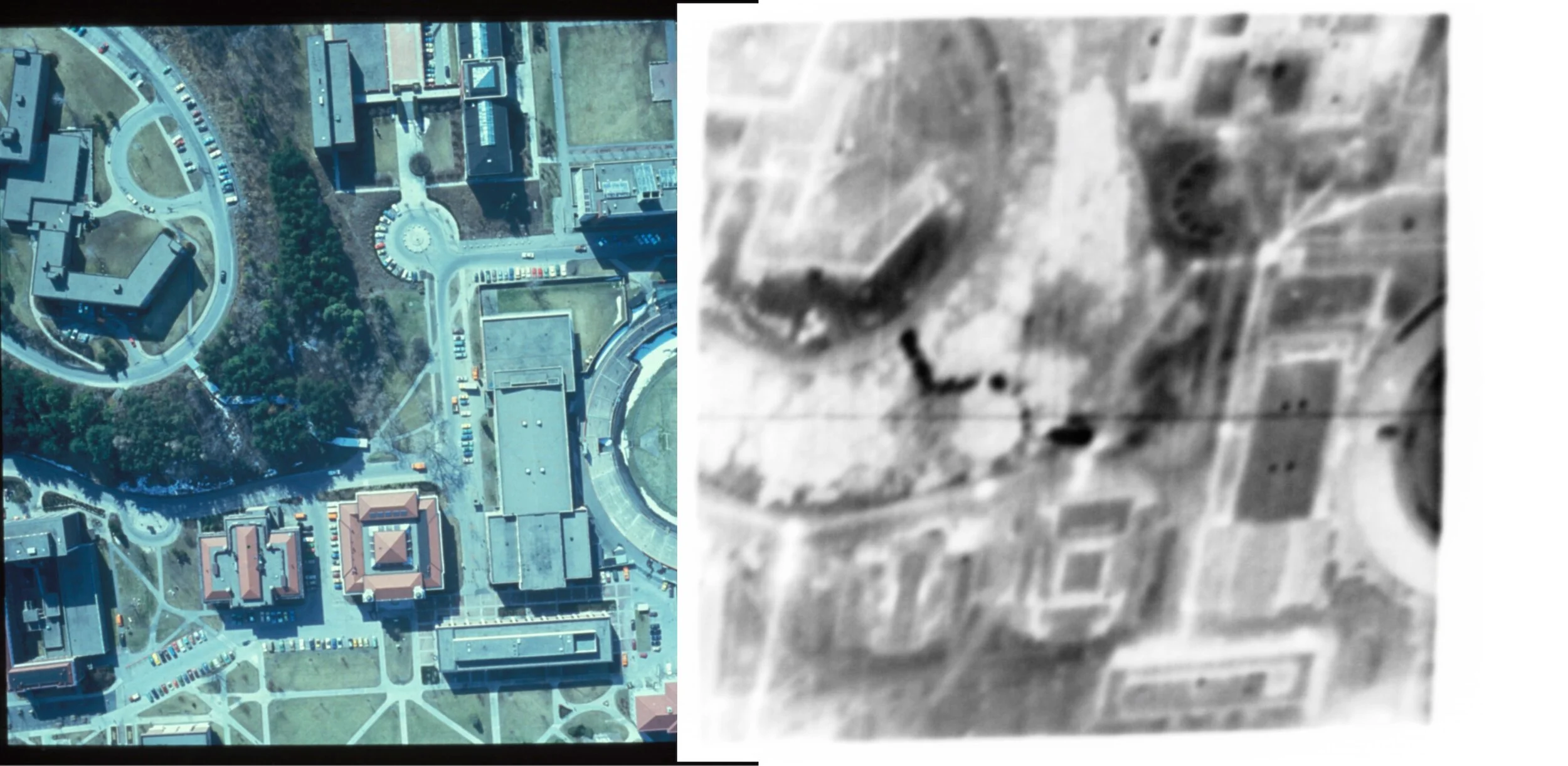
True color aerial image (left) of a portion of the Syracuse University campus including the edge of the stadium (pre-dome)and a nightime thermal image (white-hot) of the same region taken on a cold winter night. The blurry white dots roughly connected by lines are formed by the heat leaking from the underground steam pipes. The very black objects near the center are the metal roofs over a covered walkway leading down from mount Olympus at top left